Chincheros City


Chincheros, Apurimac, Peru
Suggest Place to Visit
312
Track to location with GPS |
 |
The history of Chincheros is related to Andahuaylas, by a mythical history; It is said that the settlers have left the Chocqlloqocha lagoon, in Huancavelica, located over 4000 meters above sea level, which would be their paqarina or source of origin and life; from this there is a migration to Andahuaylas in search of better lands to develop, following the direction of the Pampas River.
Towards the XIII and XV centuries, when the regional states of this area were completely formed and constituted, a contradiction arises between Chancas and the Incas of Cusco, facing long battles. The Chancas were initially located between the Pampas River and the Pachachaca River. As they expanded, they made the Andahuaylas area their main headquarters, this confederation was made up of the Hancohuallus, the Utumsullas and the Urumarcas. The initiator of the Chanca expansion was called Uscovilca, the progenitor of Anco Huayllu. This group was in charge of developing an autonomous culture and they had their own language, Puquina; and tamed the llama. Investigations carried out by J. González Carré and Lorenzo Huertas document that the influence of this nation radiated from Apurímac to Ayacucho and Huancavelica, in this way they subdued the Wankavilcas and Rukanas. After subduing the Soras, the Chancas penetrated into the lands of the Quechuas Antahuayllas, through the Chicha River, which strongly resisted the invasion of the Chancas, being defeated they emigrated to Aymaraes. Once the conquest was consolidated in the entire region, they transferred the political-military power from Vilcashuamán to Antahuaylla, place of the capital of the Chanca Tribal Confederation. This annexation occurred in the reign of Mayta Capac in the year 1300.
Being the Chanca leader Ancco Huayllu, he formed a respectable army of 40 thousand men under the command of the brothers: Asto Waraka and Tumay Waraka; In the reign of Yawar Waqaq, having knowledge that the Incas were going through political difficulties with the Wayllakanes, they hastened the war by invading Cusco, from the Antahuaylla valley, a place of sufficient supply, they went to Cusco through the Vilkakunka route, being a gate entering Ichupampa, arriving to fight in the Sacsaywuaman Fortress, where they encountered resistance, they were forced to retreat to their bases in Antahuaylla and intercepted on the way by the Inca Pachacutec, taking place the famous battle of Yawarpampa (blood field).
According to the chroniclers' account in the battle, 22 thousand Chancas and 08 thousand Cuzqueños died. Captains Asto Waraka and Tumay Waraka heroically succumbed and Ancco Huayllu was wounded and imprisoned. According to the chronicler Bernabé Cobo, he mentions a second offensive by the Chancas, led by Ancco Huayllu, who had not only managed to escape but also brought together 08,000 combatants in Challcumarca and Suramarca, this time to recover the lost territories. Finding himself at a disadvantage, he chose to escape into the jungle following the course of the Urubamba River. Their internment took place in the territories of Huallaga and from there to the jurisdiction of Lamas in the department of San Martín, where to date they keep their ethnic identity without mixing.
In the Inca period, the area was called "Ajay Pampa", because the area made liquors, derived from corn, which were called "chicha". With the arrival of the conquerors it was changed to Chincheros in honor of the chicha. During the colony, Chincheros was part of the Andahuaylas party that belonged to the Huamanga intendancy. In the Republic, the parties are transformed into provinces and the municipalities into departments. In 1846, with Supreme Decree No. 024765/46 the district of Chincheros was created, with the name VILLA CHINCHEROS. On April 28, 1873, the department of Apurímac was created, providing that the provinces of Andahuaylas, Abancay, Aymaraes, Antabamba and Cotabambas form part, the first of them belonging to the department of Ayacucho and the others to Cusco. This double origin is still visible, since Andahuaylas is geographically and culturally linked to Ayacucho, just like the province of Chincheros, while Abancay is linked to Cusco.
The ancient Chancas have left their mark on their past, which can be seen in their constructions and that to date there is a lot of scope for researchers who want to study said legendary past, in those days when the town of Chincheros did not exist, but its purely agricultural soil and its purely agricultural people attached to their land because they subsisted there helped by its pleasant climate suitable for developing agricultural activities.
Chincheros one of the 07 provinces of the department of Apurímac. Its history goes back to the first groups that would have populated the territory 5 thousand years ago; finding an area with agricultural potential. The development of these peoples settled in the region was based on agriculture, since sedentary life increased production and to ensure their food, agricultural technology was promoted, as well as increased production in the domestication of plants.
The district of Chincheros is the capital of the Province of Chincheros, department of Apurímac; to the North West of the province of Abancay, between 1000 to 4438 meters above sea level.
The province of Chincheros is located in the extreme west of the department of Apurímac. Its homonymous capital is located at 2800 meters above sea level, on the bank of the Chincheros River, which is one of the tributaries of the Pampas River. It is politically divided into 08 districts, as shown in the following table.
Geographic: The district of Chincheros is located in the Northeast part of the Apurímac Department, South Latitude 12º30´50´´ and West Longitude 73º43´13´´.
Extension and Altitude
The Chincheros district has an area of 132.40 km2, at the provincial level it represents 10.6% of 1246.77 km2, being 0.6% of 20,895.79 km2 at the departmental level. The topography is quite rugged and rugged, presenting deep ravines in the configuration of its territory.
The district geography is located in different altitudinal floors with different morphological, climatic and biogeographic characters: Yunga (between 1000 and 2500 meters above sea level), Quechua (between 2500 and 3500 meters above sea level), Suni (between 3500 and 4100 meters above sea level) and Puna (about 4100 and 4438 masl).
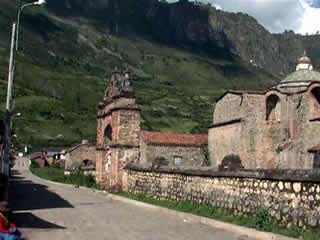
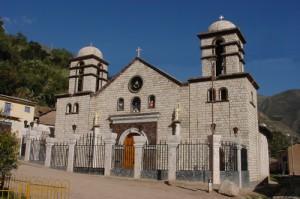
Sanctuary of Cocharcas
110 km northwest of the city of Andahuaylas (3 hours by bus).
Baroque style temple built with finely carved ashlar stone and built between 1598 and 1623. It has two towers, a semicircular vault and a masonry dome covered with glazed tiles inside which are kept important paintings from the Cusco School and from some Spanish teachers. The main altar presents ornaments finely carved in gold leaf.
.
Comments
We don´t have yet any comments about:
Chincheros City
Chincheros City
Be the first to leave a comment as it is very important to inform other people
Outros locais a visitar
Within a radius of 20 km from:Chincheros City
Sanctuary of the Virgin of Cocharcas |
| 0,8 Km |
 |
Hotel reservation near Chincheros City within a radius of 20 km
No results
Why to book with CLUBE TRAVEL
The best prices
Our partnerships with the world´s largest operators offer research on the best market prices.
More options
At Rotas Turisticos you can book the hotel, buy the air ticket, book the transfer from the airport to the hotel and vice versa, book the local excursions, rent the car, take travel insurance and consult the places to visit and where to go.
Holiday Tips & Destinations
Hundreds of holiday destinations with all the options that allow you to easily choose the destination that best suits your dream vacation.
CLUBE TRAVEL
Links
Follow us on social networks


