La Oroya, Metallurgical Capital of Peru and South America


La Oroya, Junín, Peru
La Oroya, Metallurgical Capital of Peru and South America
La Oroya, Metallurgical Capital of Peru and South America
Suggest Place to Visit
816
Track to location with GPS |
 |
In the Inca period, the dividing line between the Tarumas and Huanchorinos was the “Jatunmayo” (large river), even in the colony and in the republican era, the “Mantaro”.
Don Francisco Pizarro after signing the act of cancellation of the foundation of the city of Jauja and the subsequent transfer of the capital of Peru to Lima on November 28, 1534, left the city of Jauja towards the coast, accompanied by his Spanish lieutenants and guided by Huanca Indians of war and cargo provided by their friends the curacas, Cusichaca and Guacrapaucar, arriving the expedition to the region of "quiscas" eastern band of Jatunmayo, to pass to the western band, they saw a basket shape It hung from a marona, a rope (huasca), made of llama wool thread secured at its ends in powerful stone stakes on each side of the river and the Huanca guides, pointing to this kind of bridges, said to Pizarro in their language: " CHACA-HUARO-CHIRI TAYTA ", which translating into Spanish says:" Dad passing the bridge is cold ", the Spanish seeing that ingenious form of bridge fruit of the intellectual quality of the Andean man, shouted: a gold to! .
According to local tradition, it owes its name to a kind of suspension bridge that allows people and cargo to be transported in containers called ´´oroyas´´, which are shaped like a basket and which crossed the Mantaro river from one bank to the other. In this city, the Central Highway is divided into two branches: one goes to the city of Huancayo, capital of the region; and the other, to the central jungle of Peru, which makes La Oroya not only a point of convergence for travelers from the center of the country, but also a strategic area for commerce and industry.
La Oroya is a city in the central part of Peru, capital of the Yauli Province (Junín Department), located at 3,750 meters above sea level on the eastern slope of the Andes Mountains, on the margin of the Mantaro River. It is located in the Altiplano about 176 km northeast of the national capital, Lima.
It is nestled in the eastern foothills of the Andes Mountains. Due to its high altitude (3750 meters above sea level), its climate is frigid and rainy. It has a total area of 388.42 km².
Oroya is a form of bridge that was very similar to the oroyas that were in Spain. Using the basket, the walkers passed to the other side of the river, it was the part of Callapampa where the Huarochirí and Huanchor region began. The Spanish were pronouncing the words spoken by the Huancas and the memory of the s oroyas, a Castilian word and since then the Spaniards named this bridge: "LA OROYA", which was easier to pronounce because it was a chaste word, before Chacahuaro. Over time the place was called La Oroya.
The Chacahuaro was located on the left side of the "Cuchimachay" stream at the same point of its mouth to the Mantaro river, which at the same time served as natural protection against the erosive force of the indicated river, currently the pedestrian bridge named "Cascavel"
The shape of "Chacahuaro" underwent modifications during the colonial period, but it kept its name until 1925, the Jatunmayo or Mantaro is born from Lake Chinchaycocha, the course of its eternal waters is from north to south, in the colonial period it was the natural element of border between the western provinces of Canta and Huarochirí with the eastern one of Tarma.
The place of "quiscas", triangular in shape, has an area of more or less 8 hectares of semi-flat land, framed by the north and east with the slopes called: "Gloria-Pata", "Cayán-Pata", "Picoy-Pata ”And by the hill“ Mitojasha ”. To the south-east with the “Rayojasha” hill, at its foot the “Cuchimachay” stream slides, descending from the eastern heights and springs of Pishcapuquio.
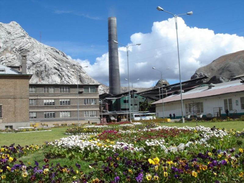
The metallurgical capital of the country, La Oroya (3 726 masl) is also the bifurcation point of the overland routes that link Junín, Tarma, Jauja and Huancayo.
It is also known for having one of the tallest chimneys in South America. Its quality as a great metallurgical center has caused one of the largest cases of contamination in Peru and the world both of the air and the soil, as well as the waters of the Mantaro and Yauli rivers, for which they lack vegetation and aquifer life . The Blacksmith Institute ranked the city of La Oroya in 2006 as one of the 5 most polluted cities in the world.
Comments
We don´t have yet any comments about:
La Oroya, Metallurgical Capital of Peru and South America
La Oroya, Metallurgical Capital of Peru and South America
Be the first to leave a comment as it is very important to inform other people
Outros locais a visitar
Within a radius of 20 km from:La Oroya, Metallurgical Capital of Peru and South America
Unfortunately we do not have information on other places to visit in this area yet
Hotel reservation near La Oroya, Metallurgical Capital of Peru and South America within a radius of 20 km
No results
Why to book with CLUBE TRAVEL
The best prices
Our partnerships with the world´s largest operators offer research on the best market prices.
More options
At Rotas Turisticos you can book the hotel, buy the air ticket, book the transfer from the airport to the hotel and vice versa, book the local excursions, rent the car, take travel insurance and consult the places to visit and where to go.
Holiday Tips & Destinations
Hundreds of holiday destinations with all the options that allow you to easily choose the destination that best suits your dream vacation.
CLUBE TRAVEL
Links
Follow us on social networks


